Living On The Edge: Earthquakes Near The Iran-Iraq Border
Table of Contents
- Introduction: The Earth's Unsettling Rhythms
- The Geological Heartbeat: Why the Iran-Iraq Border Trembles
- The Devastating 2017 Quake: A Closer Look at the Iran-Iraq Border Earthquake
- Beyond 2017: A Region Prone to Tremors
- Monitoring and Forecasting: Can We Predict the Next Iran-Iraq Border Earthquake?
- Building Resilience: Preparing for the Unpredictable
- The Human Toll and Long-Term Recovery
- Looking Ahead: Living with Seismic Activity
- Conclusion: A Call for Continued Vigilance
Introduction: The Earth's Unsettling Rhythms
The very ground beneath our feet, often taken for granted as solid and unmoving, can unleash a terrifying force capable of reshaping landscapes and lives in mere seconds. Nowhere is this reality more starkly felt than along the volatile boundary between Iran and Iraq, a region perpetually on the brink of seismic upheaval. This geographical fault line has, time and again, reminded its inhabitants of nature's raw power, with the most recent major event in 2017 serving as a harrowing testament to the destructive potential of an earthquake near the Iran-Iraq border.
For centuries, communities nestled in the mountainous terrains spanning these two nations have adapted to a life intertwined with the Earth's restless movements. While smaller tremors are a common occurrence, occasionally, a truly colossal event strikes, leaving a trail of devastation and a profound impact on the affected populations. Understanding the geological forces at play, the historical context of these events, and the critical importance of preparedness becomes paramount for anyone living in or studying this seismically active region.
The Geological Heartbeat: Why the Iran-Iraq Border Trembles
The Earth's crust is not a single, solid shell, but a mosaic of massive plates constantly grinding against each other. This intricate dance of tectonic plates is the primary driver behind earthquakes, and the Iran-Iraq border region sits squarely on one of the planet's most active collision zones. Specifically, the U.S. Geological Survey (USGS) highlights that in this area, the Arabian plate is relentlessly moving towards the north with respect to the Eurasian plate at an approximate rate of 26 millimeters per year. This seemingly slow, inch-by-inch movement might appear insignificant, but over geological timescales, it builds up immense stress along the fault lines where these two colossal landmasses meet. When this accumulated stress finally exceeds the strength of the rocks, it releases suddenly in the form of seismic waves, which we experience as an earthquake. The Zagros Mountains, which form a significant part of the border between Iran and Iraq, are a direct result of this ongoing collision. This mountain range is riddled with active fault lines, making it a hotbed for seismic activity. Therefore, when we talk about an earthquake Iran Iraq border, we are referring to a predictable, albeit unpredictable in timing, consequence of fundamental geological processes. It's a region where the Earth is literally being crumpled and uplifted, and tremors are merely the audible groans of this colossal geological construction project.The Devastating 2017 Quake: A Closer Look at the Iran-Iraq Border Earthquake
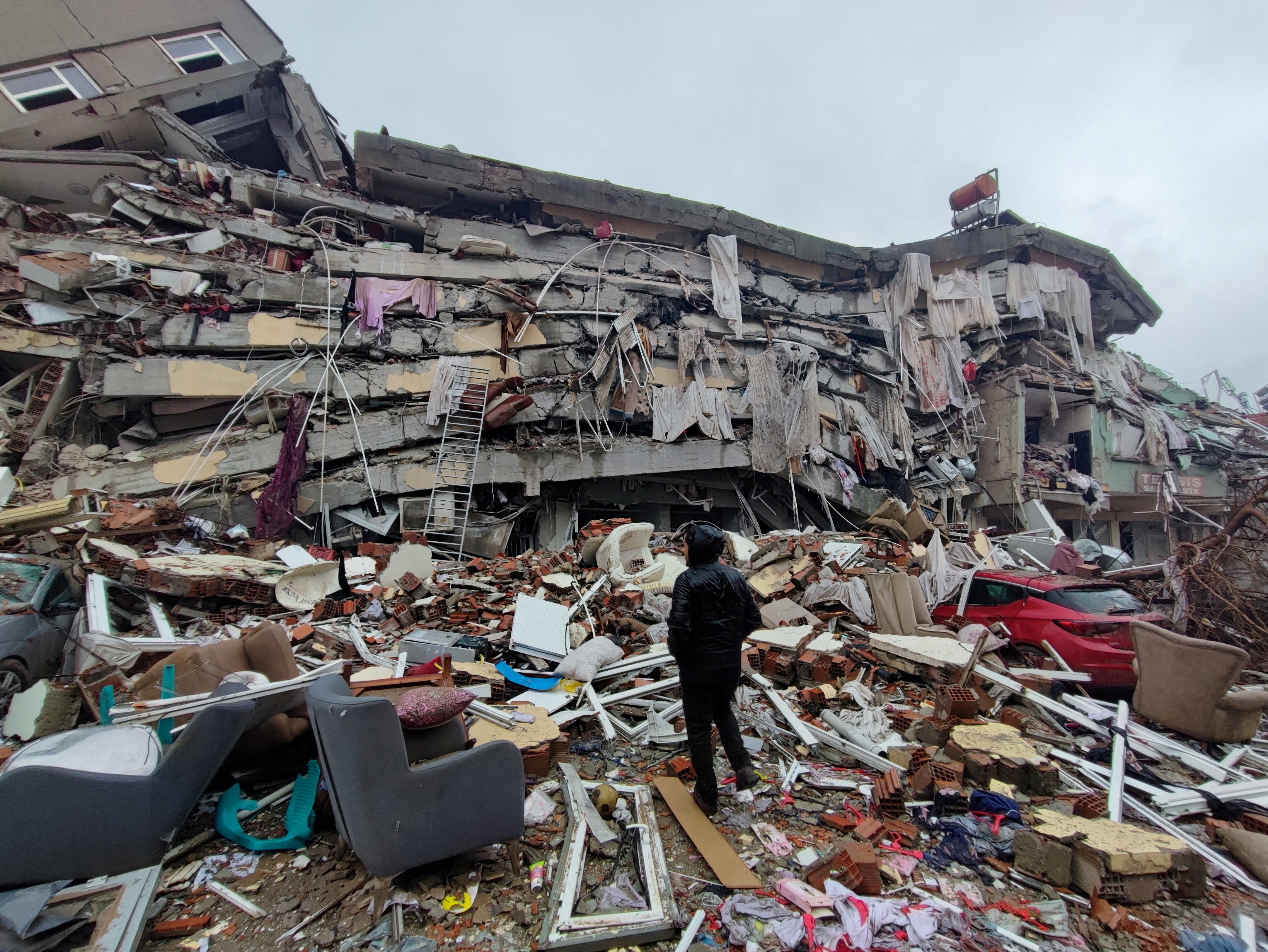
One of the most significant and recent reminders of the region's seismic vulnerability occurred on November 12, 2017. A powerful 7.3 magnitude earthquake struck Iran’s mountainous western region near the Iraqi border. The temblor happened at 9:19 p.m. Iran time, about 22 miles southwest of Halabja, a city that tragically became a focal point of the disaster. This event, which registered as a major earthquake of magnitude M 7.3, caused widespread panic and destruction across a vast area. The initial reports were grim, and as rescue efforts began, the true scale of the catastrophe began to unfold. This event destroyed many buildings around Sarpol Zahab city, a community that bore the brunt of the structural damage and collapse in Iran. The sheer force of the quake, felt hundreds of miles away, highlighted the vulnerability of infrastructure not built to withstand such intense shaking. News reports and official statements painted a picture of widespread devastation, with collapsed homes, damaged roads, and communities cut off from aid.Immediate Aftermath and Rescue Efforts
In the immediate aftermath, the focus shifted to search and rescue. Rescue teams in Iran swiftly mobilized, looking for people trapped in collapsed buildings. A huge rescue effort was underway after the powerful earthquake struck Iran's mountainous border with Iraq. The challenging mountainous terrain, combined with the late hour of the quake, complicated these efforts. Every minute counted as responders desperately tried to reach survivors buried under rubble. As the days progressed, the grim toll became clearer. Iranian media on Tuesday increased the death count, reflecting the ongoing recovery of bodies from the debris. Initially, authorities reported around 400 fatalities, but the numbers tragically climbed. Iran’s western Kermanshah province bore the brunt of the temblor Sunday night, with authorities saying the quake killed 407 people in the country and injured 6,700. However, as the search continued and more remote areas were accessed, the official count tragically rose. This event ultimately killed at least 530 people and injured thousands across the affected regions in Iran, making it one of the deadliest earthquakes in recent Iranian history. The scale of human suffering was immense, with families torn apart and communities grappling with unimaginable loss.Disparate Impact: Iran vs. Iraq
While the earthquake struck near the border with Iraq, the impact was notably different on either side. On 12th of November 2017, a major earthquake of a magnitude of M 7.3 hit Halabja and caused severe structural damage and collapse in Iran. However, across the border in Iraq, only a few areas were mildly affected. The Baghdad government did not immediately give word on damage or casualties in that country, indicating a less severe impact compared to its neighbor. This disparity can be attributed to several factors, including the precise location of the epicenter relative to population centers and the geological characteristics of the underlying land. While the quake's energy propagated in all directions, specific fault lines and the composition of the earth's crust can dictate how seismic waves travel and where the most intense shaking occurs. In this instance, Iran's western provinces, particularly Kermanshah, found themselves directly in the path of the most destructive forces, leading to a much higher casualty count and more extensive damage.Beyond 2017: A Region Prone to Tremors
While the 2017 earthquake remains a vivid memory of the destructive power of an earthquake Iran Iraq border, it is crucial to understand that seismic activity is a constant feature of this region. The provided data gives us a snapshot of this ongoing reality: * (M1.5 or greater) 0 earthquakes in the past 24 hours. * 0 earthquakes in the past 7 days. * 1 earthquake in the past 30 days. * 23 earthquakes in the past 365 days (in one dataset). * Another dataset states: Iran Iraq border has had (M1.5 or greater) 0 earthquakes in the past 24 hours, 8 earthquakes in the past 365 days. These figures, even with slight variations between different reporting periods or criteria, clearly indicate that while major, devastating quakes like the M7.3 in 2017 are rare, smaller tremors are a regular occurrence. The region experiences numerous minor quakes that often go unnoticed by the general public or cause minimal damage. However, these constant smaller movements are a perpetual reminder of the underlying geological forces at play. The question "Quakes near Iran Iraq border now, today, and recently?" or "See if there was there an earthquake just now in Iran Iraq border?" are common queries that reflect the public's awareness and concern about the ongoing seismic activity. Websites and apps dedicated to earthquake monitoring are popular tools for residents seeking real-time information. The biggest earthquakes in Iran Iraq border history are often etched into the collective memory of the local populations, shaping their understanding of their environment and influencing building practices, even if informally. This consistent seismic background underscores the necessity for robust preparedness measures, not just for the rare catastrophic event, but for the cumulative impact of frequent smaller tremors as well.Monitoring and Forecasting: Can We Predict the Next Iran-Iraq Border Earthquake?
The science of seismology has made incredible strides in understanding how earthquakes occur, where they are likely to happen, and their potential magnitude. Agencies like the U.S. Geological Survey (USGS) and their international counterparts maintain sophisticated networks of seismographs that continuously monitor ground motion across the globe, including the Iran-Iraq border region. These networks allow scientists to quickly detect and locate earthquakes, providing vital information for emergency responders and the public. However, despite these advancements, the precise prediction of earthquakes—knowing exactly when and where a specific earthquake will strike—remains an elusive goal. While scientists can identify areas of high seismic risk, like the Iran-Iraq border, and estimate the probability of a major earthquake occurring within a certain timeframe (e.g., decades), they cannot predict the exact day, hour, or minute. The complexities of rock mechanics, stress accumulation, and fault behavior are too intricate for current scientific models to forecast with such precision. Instead, the focus is on forecasting and early warning systems. Early warning systems, which detect the initial, faster-moving P-waves of an earthquake and issue alerts before the slower, more destructive S-waves arrive, can provide precious seconds or even minutes of warning. While these systems are still developing and have limitations, particularly for areas very close to the epicenter, they offer a promising avenue for mitigating casualties by allowing people to take immediate protective actions. For a region like the Iran-Iraq border, investing in such technologies and educating the public on how to respond to these alerts could be life-saving.Building Resilience: Preparing for the Unpredictable
Given the impossibility of precise earthquake prediction, the most effective strategy for mitigating their impact lies in preparedness and building resilience. For communities living in seismically active zones like the Iran-Iraq border, this means a multi-faceted approach involving government policies, infrastructure development, and public education. One of the most critical aspects is the enforcement of stringent building codes. Structures designed and constructed to withstand seismic forces are far less likely to collapse, significantly reducing casualties and economic losses. This includes using flexible materials, reinforcing foundations, and ensuring proper engineering practices. While implementing and enforcing such codes can be challenging, especially in developing regions or areas with older infrastructure, it is a non-negotiable investment in safety. The stark difference in damage between Iran and Iraq during the 2017 quake, where Iran experienced severe structural damage and collapse while Iraq was mildly affected, might partly be attributed to variations in building resilience and the specific geological conditions.Community Engagement and Education
Beyond structural integrity, public awareness and education are paramount. People need to know what to do before, during, and after an earthquake. This includes simple yet life-saving actions like "Drop, Cover, and Hold On" during shaking, having emergency kits readily available, and knowing evacuation routes. Regular earthquake drills in schools, workplaces, and communities can instill these habits, ensuring that instinctive, life-preserving actions are taken when a tremor strikes. Educating the public about the risks associated with an earthquake Iran Iraq border and fostering a culture of preparedness can significantly reduce panic and improve survival rates.The Role of International Aid and Cooperation
Earthquakes often transcend national borders in their impact, and the Iran-Iraq border region is a prime example. When a major event occurs, international aid and cooperation become crucial. Humanitarian organizations, medical teams, and search-and-rescue experts from around the world often deploy to assist affected countries. This collaboration can provide much-needed resources, expertise, and support for overwhelmed local authorities. Furthermore, cross-border cooperation between Iran and Iraq in disaster response, information sharing, and long-term recovery planning is vital for a region that shares a common geological fate. Such collaboration can streamline aid delivery, coordinate rescue efforts, and facilitate a more effective and humane response to future seismic events.The Human Toll and Long-Term Recovery
The immediate aftermath of an earthquake, with its collapsed buildings and frantic rescue efforts, is only the beginning of a long and arduous journey. The human toll extends far beyond the initial casualties and injuries. Thousands are left homeless, their livelihoods destroyed, and their lives irrevocably altered. The psychological impact of experiencing such a terrifying event, losing loved ones, and witnessing widespread destruction can lead to long-term trauma, anxiety, and depression. Children, in particular, are vulnerable to the lasting emotional scars of such disasters. Rebuilding communities after a major earthquake, like the one that struck the Iran-Iraq border in 2017, is a monumental task. It involves not only constructing new homes and infrastructure but also restoring essential services, reviving local economies, and providing psychological support to the affected population. This process can take years, even decades, and requires sustained commitment from governments, non-governmental organizations, and the international community. The resilience of the human spirit is often highlighted during these times, as communities come together to support each other and slowly piece their lives back together. However, the path to full recovery is often fraught with challenges, including funding limitations, political complexities, and the sheer scale of the destruction.Looking Ahead: Living with Seismic Activity
The Iran-Iraq border will continue to be a region of significant seismic activity. The geological forces driving the collision of the Arabian and Eurasian plates are relentless and will persist for millions of years to come. Therefore, the question is not if another earthquake will strike, but when, and how prepared the communities will be. Continuous investment in seismic research, advanced monitoring technologies, and early warning systems is crucial. Equally important is the ongoing enforcement of robust building codes, especially in new construction and the retrofitting of existing structures. Public education campaigns must be sustained, ensuring that new generations are aware of the risks and equipped with the knowledge and skills to respond effectively. For the residents of this beautiful yet challenging region, living with the threat of an earthquake Iran Iraq border is a part of life. Their ability to adapt, prepare, and recover will define their future resilience in the face of nature's formidable power.Conclusion: A Call for Continued Vigilance
The powerful 7.3 magnitude earthquake that struck the Iran-Iraq border in 2017 served as a stark and tragic reminder of the immense geological forces at play in this volatile region. With over 530 lives lost and thousands injured, the event underscored the critical need for preparedness, resilient infrastructure, and informed communities. While the frequency of major quakes is relatively low, the constant smaller tremors confirm that the Earth's tectonic plates are ceaselessly at work beneath the surface. Understanding the "why" behind an earthquake Iran Iraq border – the relentless northward movement of the Arabian plate – empowers us to better prepare for the "when." From strengthening building codes to fostering a culture of public readiness, every measure taken contributes to saving lives and mitigating devastation. The human spirit's capacity for resilience in the face of such overwhelming natural disasters is profound, yet it must be supported by robust governmental policies and international cooperation. Let the lessons learned from past tremors, particularly the devastating 2017 event, serve as a perpetual call to action, urging continued vigilance and proactive measures to protect the lives and livelihoods of those living on the edge of the Earth's powerful, unsettling rhythms. What are your thoughts on earthquake preparedness in seismically active regions? Share your insights and experiences in the comments below, or consider sharing this article to raise awareness about this vital topic./nepal-earthquake-2015-858240192-f0cb035a5cd94de98e2ac2ed0f8fe9bc.jpg)
15 Groundbreaking Earthquake Facts

Nature At Its Most Devastating: The Science Of Earthquakes
Pope saddened by 'huge loss of life' after earthquakes in Turkey and
