Kermanshah Earthquake: Unveiling Iran's Seismic Story
Table of Contents
- Kermanshah: A Seismically Active Region
- The Devastating 2017 Kermanshah Earthquake: A Deep Dive
- Aftermath and Humanitarian Response
- Historical Seismic Activity in Kermanshah
- Frequency of Earthquakes in Kermanshah
- Recent Seismic Events Near Kermanshah
- Preparing for Future Earthquakes: Lessons Learned
- Conclusion
Kermanshah: A Seismically Active Region
Kermanshah, a province in western Iran, is situated in a region characterized by significant seismic activity. Its location within the Zagros fold-and-thrust belt, a major active mountain range, means that it is constantly subjected to the immense pressures generated by the collision of the Arabian and Eurasian tectonic plates. This geological context is fundamental to understanding why earthquakes are such a frequent occurrence here. The landscape itself, with its rugged mountains and valleys, bears witness to millions of years of tectonic forces at play. The underlying geology of Kermanshah, with its complex network of faults, acts as a conduit for seismic energy release. These faults, essentially fractures in the Earth's crust, are where the accumulated stress from plate movements is suddenly discharged, resulting in an earthquake. The frequency and intensity of these events are directly linked to the rate of plate convergence and the characteristics of these fault systems. While smaller tremors are common, the potential for larger, more destructive events always looms, necessitating robust preparedness and response mechanisms.Understanding Iran's Tectonic Setting
Iran sits on two major tectonic plates, the Eurasian Plate and the Arabian Plate. The ongoing collision between these two colossal geological entities is the primary driver of the country's high seismicity. The Arabian Plate is moving northward, pushing against the Eurasian Plate, causing the crust to buckle, fold, and fracture. This process has not only created the majestic Zagros Mountains but also numerous active fault lines that crisscross the Iranian plateau. The Zagros fold-and-thrust belt, where Kermanshah is located, is one of the most active zones of this collision. Here, the deformation is distributed across a wide area, leading to both shallow and intermediate-depth earthquakes. The United States Geological Survey (USGS) has extensively documented the fault systems in Iran, highlighting the complex interplay of various fault segments that can rupture individually or in tandem, leading to earthquakes of varying magnitudes. This continuous geological stress means that approximately 192 quakes on average occur per year in or near Kermanshah, Iran, based on data from the past 14 years and earthquake archives dating back to 1900. This high frequency, though often involving smaller tremors, underscores the constant seismic background noise that residents of the region live with.The Devastating 2017 Kermanshah Earthquake: A Deep Dive
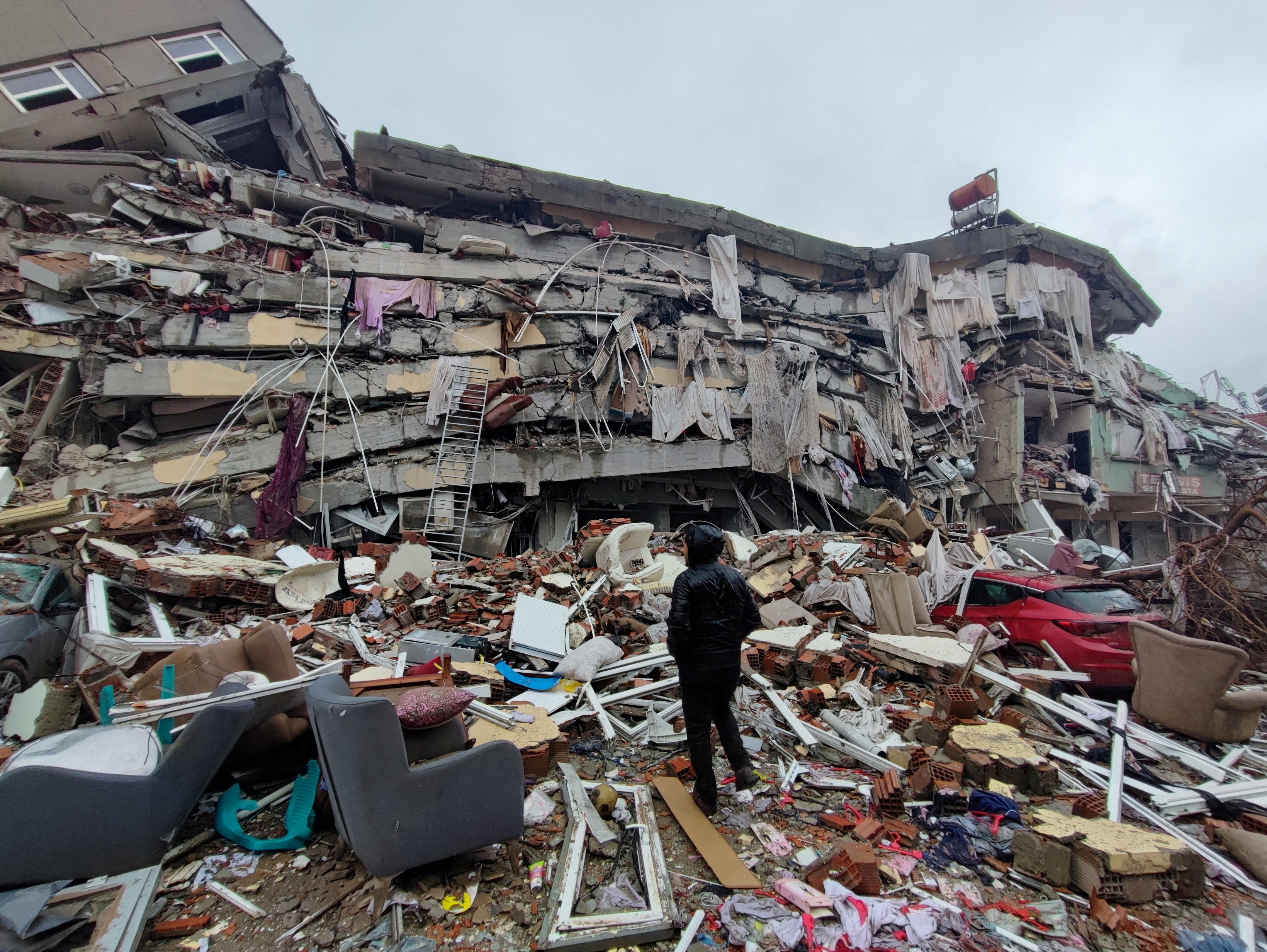
The strongest recent earthquake of the past 10 years near Kermanshah occurred on November 12, 2017. This event stands as a stark reminder of the destructive power of nature and the vulnerability of human settlements. It was not just a geological event but a profound human tragedy that garnered international attention and triggered a massive humanitarian response. The earthquake's impact was felt far beyond the immediate epicenter, reaching across several regions and causing widespread alarm. The event unfolded on a Sunday evening, disrupting the lives of millions and forever changing the landscape of several towns and villages. Its magnitude and shallow depth amplified its destructive potential, leading to extensive damage and a significant loss of life. The 2017 Kermanshah earthquake serves as a critical case study for understanding seismic hazards in the region and for improving future disaster preparedness and response strategies.Chronology and Initial Impact
The powerful 7.3 magnitude earthquake struck Iran near the border with Iraq on November 12, 2017, at 21:48:16 Iran Standard Time (9:48 p.m. local time, which was 1:18 p.m. Eastern Standard Time). The temblor happened about 22 miles southwest of the city, near Ezgeleh, in Kermanshah Province. The suddenness of the event, occurring in the evening when many people were indoors, contributed to the high casualty figures. Initial reports and early estimates painted a grim picture. Over 400 lives were lost, and over 6,600 people were injured in the immediate aftermath. However, as rescue efforts continued and more information became available, the true scale of the tragedy became clearer. Later estimates indicated that between 600 to 700 people were killed, and more than 10,000 injured. The discrepancy in figures often reflects the chaotic nature of immediate post-disaster assessments and the challenges of accurate reporting in affected areas. Shaking was felt across several regions, causing panic and widespread damage to infrastructure, particularly in rural areas where building codes might have been less stringent or older structures were more prevalent. The collapse of homes, schools, and hospitals left thousands homeless and in urgent need of aid.Magnitude and Epicenter Details
The strongest earthquake recorded near Kermanshah was indeed this 7.30 magnitude earthquake. The Iranian Seismological Center (IRSC) estimated a moment magnitude of 7.3 and an epicenter located at 34.77°N and 45.76°E at a depth of 18 km. This precise location places the epicenter near Ezgeleh, a town in the Kermanshah Province. The United States Geological Survey (USGS) estimated an identical moment magnitude of 7.3 but placed the epicenter slightly differently, at 34.81°N and 45.91°E, which is approximately 14.4 km to the northeast of the IRSC's estimated location. While these slight differences in epicenter coordinates are common among different seismic agencies due to variations in their monitoring networks and processing algorithms, both organizations agreed on the significant magnitude of the event and its relatively shallow depth of 19.0 kilometers (or 18 km as per IRSC). A shallow depth means that the seismic energy is released closer to the surface, leading to more intense shaking and greater potential for destruction in the affected areas. The USGS event page and their Prompt Assessment of Global Earthquakes for Response (PAGER) website provide comprehensive information on casualties and damage estimates, serving as crucial resources for understanding the full scope of the disaster.Aftermath and Humanitarian Response
The immediate aftermath of the 2017 Kermanshah earthquake was characterized by chaos and urgent calls for assistance. Thousands of people were left without shelter, food, and medical care. The sheer scale of the damage, particularly in rural areas, overwhelmed local resources, necessitating a robust national and international humanitarian response. Rescue teams worked tirelessly, often in challenging conditions, to pull survivors from the rubble. The response involved various government agencies, non-governmental organizations (NGOs), and volunteers. Emergency shelters were set up, and essential supplies like tents, blankets, and food aid were distributed. Medical teams were deployed to treat the injured, many of whom suffered severe trauma. The long-term recovery efforts involved rebuilding homes, schools, and infrastructure, a process that takes years and significant investment. The human element of the disaster was also a focus for researchers; one study, for instance, employed a purposive sampling approach, specifically using maximum variation based on factors such as sex, marital status, years of work experience, and presence during the Kermanshah earthquake, to conduct interviews and understand the lived experiences of those affected. This highlights the importance of not just physical recovery but also addressing the psychological and social impacts on the community.Historical Seismic Activity in Kermanshah
While the 2017 earthquake was the most significant recent event, Kermanshah has a long history of seismic activity. Understanding this historical context is vital for assessing the long-term seismic risk of the region. Records dating back to the early 20th century reveal a pattern of both frequent minor tremors and infrequent but powerful major earthquakes. This historical data provides crucial insights into the recurrence intervals of large-magnitude events and helps in seismic hazard assessment. The geological forces that caused the 2017 earthquake have been at play for millions of years, shaping not only the landscape but also the historical narrative of the region. Past earthquakes have undoubtedly influenced settlement patterns, building practices, and the collective memory of the communities living there. Studying these historical events helps seismologists and urban planners anticipate future risks and develop more resilient infrastructure.Past Major Quakes
Kermanshah has had at least 7 quakes above magnitude 6 since 1900. This suggests that larger earthquakes of this size occur infrequently, probably on average approximately every 15 to 20 years. While the specific details of all these historical quakes may not be as readily available as the 2017 event, their occurrence underscores the inherent seismic risk of the region. These past events, though perhaps less documented in modern media, would have caused significant disruption and damage in their time, shaping the resilience and adaptive strategies of the local population. The pattern of these larger quakes, occurring every one to two decades, highlights the cyclical nature of seismic activity in the area. It also emphasizes the importance of continuous monitoring and the implementation of strict building codes to mitigate the impact of future events. Historical data, even if sparse, provides invaluable information for long-term urban planning and disaster preparedness. For instance, the USGS has compiled data on earthquakes in Iran from 1990 to 2006, detailing the fault lines that have been active, which further illustrates the pervasive nature of seismic events across the country.Frequency of Earthquakes in Kermanshah
The data unequivocally shows that Kermanshah is a region of high seismic frequency. Based on extensive archives, there are about 192 quakes on average per year in or near Kermanshah, Iran, with magnitudes of 1.5 or greater. This high number indicates a constant background of seismic activity, most of which are minor tremors that are barely felt or cause no damage. These smaller quakes are a natural release of tectonic stress, but they also serve as a constant reminder of the larger forces at play. While the average annual number is high, the distribution of these quakes varies. For instance, recent data indicates fluctuations: * **Past 24 hours:** 2 earthquakes (m1.5 or greater) * **Past 7 days:** 4 earthquakes (m1.5 or greater) * **Past 30 days:** 9 earthquakes (m1.5 or greater) * **Past 365 days:** 120 earthquakes (m1.5 or greater) It's worth noting that another data point suggested "0 earthquakes in the past 24 hours, 0 in the past 7 days, 0 in the past 30 days, and 8 in the past 365 days" for m1.5 or greater. This discrepancy highlights the dynamic nature of seismic activity and how quickly the numbers can change, or potentially different reporting thresholds or timeframes. However, the general consensus from historical data is that the region experiences a significant number of seismic events annually. The infrequent occurrence of very large quakes (above magnitude 6) every 15 to 20 years, contrasted with the high frequency of smaller tremors, defines the seismic character of Kermanshah.Recent Seismic Events Near Kermanshah
Even after the major 2017 event, seismic activity continues near Kermanshah. These more recent tremors, while not as devastating as the 2017 earthquake, serve as a continuous reminder of the region's dynamic geology. They also provide valuable data for seismologists to monitor fault lines and understand the ongoing stress accumulation and release. One notable recent event was an earthquake with a magnitude of 5.1 on the Richter scale that struck western Iran's Kermanshah province early on a Monday, according to state media. Separately, a 5.2 magnitude earthquake has also struck Iran, with its epicenter reported near Kermanshah province, causing shaking felt across several regions. These events, though moderate in magnitude, are significant enough to cause concern and minor damage, especially to vulnerable structures. As for the very last earthquake in Kermanshah, Iran, it was reported to be 2 months ago, striking 213 km (132 mi) southeast of the city. This earthquake had a magnitude of 4.00 on the Richter scale and a depth of 10.0 km. Another data point indicates a 3.4 magnitude earthquake hit near Kermanshah on the morning of June 11, 2025, at 08:36 local time (Asia/Tehran). While this date is in the future, it highlights the continuous nature of seismic data collection and perhaps predictive modeling or a forward-looking data entry. For current and historical purposes, the "2 months ago" event is the most recent confirmed past earthquake. These ongoing tremors, even if minor, keep the community vigilant and reinforce the need for constant preparedness.Preparing for Future Earthquakes: Lessons Learned
Living in a seismically active region like Kermanshah necessitates a proactive approach to earthquake preparedness. The devastating impact of the 2017 earthquake served as a harsh lesson, highlighting critical areas for improvement in disaster management, infrastructure resilience, and public awareness. Learning from such events is paramount to mitigating future risks and protecting lives. Key lessons learned include: * **Enforcement of Building Codes:** The differential impact of the 2017 earthquake on various structures underscored the critical importance of strict adherence to earthquake-resistant building codes. Modern, well-constructed buildings often fared much better than older, traditional structures, particularly in rural areas. * **Public Awareness and Education:** Educating the public on what to do before, during, and after an earthquake is vital. Simple actions like "drop, cover, and hold on" can save lives. Community-level drills and awareness campaigns can significantly improve response times and reduce panic. * **Early Warning Systems:** While predicting earthquakes remains a scientific challenge, developing and implementing early warning systems, even if they offer only a few seconds of notice, can be invaluable for critical infrastructure and public safety. * **Robust Emergency Response:** The coordination between various emergency services, including search and rescue teams, medical personnel, and humanitarian aid organizations, is crucial for an effective post-earthquake response. Lessons from 2017 have likely led to improved protocols and resource allocation. * **Long-Term Recovery Planning:** Beyond immediate relief, comprehensive long-term recovery plans are essential. These include psychological support for survivors, economic rehabilitation, and sustainable rebuilding efforts that consider future seismic risks. * **International Cooperation:** Given the transboundary nature of some earthquakes, like the 2017 event near the Iraq border, international cooperation in seismic monitoring, data sharing, and disaster response is increasingly important. The ongoing seismic activity, including the recent tremors, reinforces the need for continuous vigilance and adaptation. While the Earth's movements cannot be stopped, their impact can be significantly reduced through informed policies, resilient infrastructure, and a well-prepared populace.Conclusion
The story of the earthquake in Iran, particularly in the Kermanshah region, is a compelling narrative of geological power and human resilience. From the devastating 7.3 magnitude event of November 12, 2017, which tragically claimed hundreds of lives and injured thousands, to the continuous smaller tremors that punctuate daily life, Kermanshah stands as a testament to the dynamic forces shaping our planet. Its location on active tectonic plate boundaries ensures that seismic activity will remain an integral part of its identity. Understanding the historical patterns, the frequency of quakes (averaging around 192 per year), and the specific details of major events like the 2017 earthquake provides invaluable insights into living with seismic risk. While the challenges are immense, the lessons learned from past disasters are crucial for building a more resilient future. By enforcing stringent building codes, enhancing public awareness, and strengthening emergency response mechanisms, communities in Kermanshah and across Iran can better prepare for and mitigate the impact of future seismic events. We invite you to share your thoughts and experiences in the comments below. Have you or someone you know been affected by an earthquake in a seismically active region? What lessons do you believe are most important for communities to learn? For more information on seismic activity and preparedness, we encourage you to explore resources from reputable organizations like the United States Geological Survey (USGS).- Xxbritz
- Is Jonathan Roumie Married
- Jesse Metcalfe Children
- How Did Bloodhound Lil Jeff Die
- Jess Brolin
/nepal-earthquake-2015-858240192-f0cb035a5cd94de98e2ac2ed0f8fe9bc.jpg)
15 Groundbreaking Earthquake Facts

Nature At Its Most Devastating: The Science Of Earthquakes
Pope saddened by 'huge loss of life' after earthquakes in Turkey and
