The 2017 Iran Earthquake: Unveiling A Nation's Seismic Vulnerability
Table of Contents
- Introduction
- A Nation on Fault Lines: Why Iran is Prone to Earthquakes
- The Devastating 2017 Kermanshah Earthquake: A Closer Look
- Geological Mechanisms Behind the Quake: Thrust Faulting
- A History of Seismic Activity in Iran
- Response and Recovery Efforts
- Lessons Learned and Future Preparedness
- Global Context and Comparisons
- Conclusion
Introduction
On a quiet Sunday evening, November 12, 2017, at precisely 21:48 local time, the ground beneath western Iran and the border region with Iraq began to violently shake. What unfolded was one of the most significant and devastating natural disasters of the year, an event that profoundly impacted thousands of lives and brought into sharp focus the inherent seismic risks faced by the nation. The 2017 Iran earthquake, centered in Kermanshah province, served as a stark reminder of the immense power of geological forces and the vulnerability of human settlements built upon active fault lines.
This powerful tremor, registered at a magnitude of 7.3, not only claimed hundreds of lives and injured thousands more but also left a trail of widespread destruction across an already challenging landscape. Understanding the intricacies of this event – from its geological origins to its far-reaching humanitarian consequences – is crucial for appreciating the challenges Iran faces and the ongoing efforts to build resilience in the face of nature's formidable power. This article delves deep into the specifics of the 2017 Iran earthquake, exploring why Iran is so prone to such seismic activity, the immediate aftermath, and the long-term lessons learned.
A Nation on Fault Lines: Why Iran is Prone to Earthquakes
To comprehend the severity and frequency of seismic events in Iran, including the impactful 2017 Iran earthquake, one must first grasp the underlying geological reality of the region. Iran is not merely located in an earthquake-prone zone; it is, in fact, one of the most seismically active countries globally. This isn't a matter of chance but a direct consequence of its geographical position at the convergence of major tectonic plates.
The primary culprit behind Iran's relentless seismic activity is the ongoing collision between the Arabian Plate and the Eurasian Plate. The Arabian Plate is steadily pushing northward into the Eurasian Plate, causing immense compression and deformation of the Earth's crust across the Iranian plateau. This colossal geological struggle doesn't manifest as one smooth, continuous movement; instead, the stress builds up along numerous faults, which are fractures in the Earth's crust where blocks of rock have moved relative to each other.
According to the United States Geological Survey (USGS), Iran is crisscrossed by several major faults that collectively cover at least 90% of the country. These include the prominent Zagros fold-and-thrust belt in the west and southwest, the Alborz mountains in the north, and various other active fault systems running through central and eastern Iran. The Zagros fault, in particular, is a major player in the region's seismicity, and it was indeed the probable source of the 2017 Iran earthquake. This complex network of faults means that stress can accumulate and be released in various locations, leading to frequent and often destructive earthquakes.
The movement along these faults is typically characterized by thrust faulting, where one block of the Earth's crust is pushed up and over another. This type of movement is indicative of compressional forces, which are abundant in Iran due to the ongoing plate collision. The energy released during these sudden slips along fault lines is what we experience as earthquakes. Because Iran sits directly on these active boundaries, earthquakes occur often and are unfortunately, often destructive, making seismic preparedness a perpetual necessity for the nation.
- Is Jonathan Roumie Married
- Averyleigh Onlyfans Sex
- Allmoveishub
- Abby And Brittany Hensel Died
- Yinyleon Height
The Devastating 2017 Kermanshah Earthquake: A Closer Look
The 2017 Iran earthquake stands out as a particularly tragic chapter in the country's seismic history. It wasn't just another tremor; it was the deadliest earthquake of 2017 globally and one of the largest ever recorded in the border region between Iran and Iraq. Its impact resonated far beyond the immediate epicentral area, affecting communities and infrastructure across a wide expanse.
Magnitude and Epicenter: The Heart of the Tremor
The 2017 Iran earthquake registered a formidable magnitude of 7.3 on the Richter scale. This places it firmly in the category of "major" earthquakes, capable of causing severe damage over a large area. The epicenter of this powerful quake was located in Kermanshah province, specifically near the town of Ezgeleh, close to the Iran-Iraq border. The precise time of the quake was 21:48 local time (Asia/Tehran timezone) on Sunday, November 12, 2017. This timing, late in the evening, unfortunately meant that many people were at home, increasing the potential for casualties as buildings collapsed.
The depth of the earthquake also played a crucial role in its destructive power. While specific depth figures vary slightly between different seismic agencies, it was generally considered a relatively shallow earthquake, which typically results in more intense shaking at the surface. Shallow quakes transmit more of their energy directly upwards, leading to more severe ground motion and greater damage to buildings and infrastructure compared to deeper earthquakes of similar magnitude.
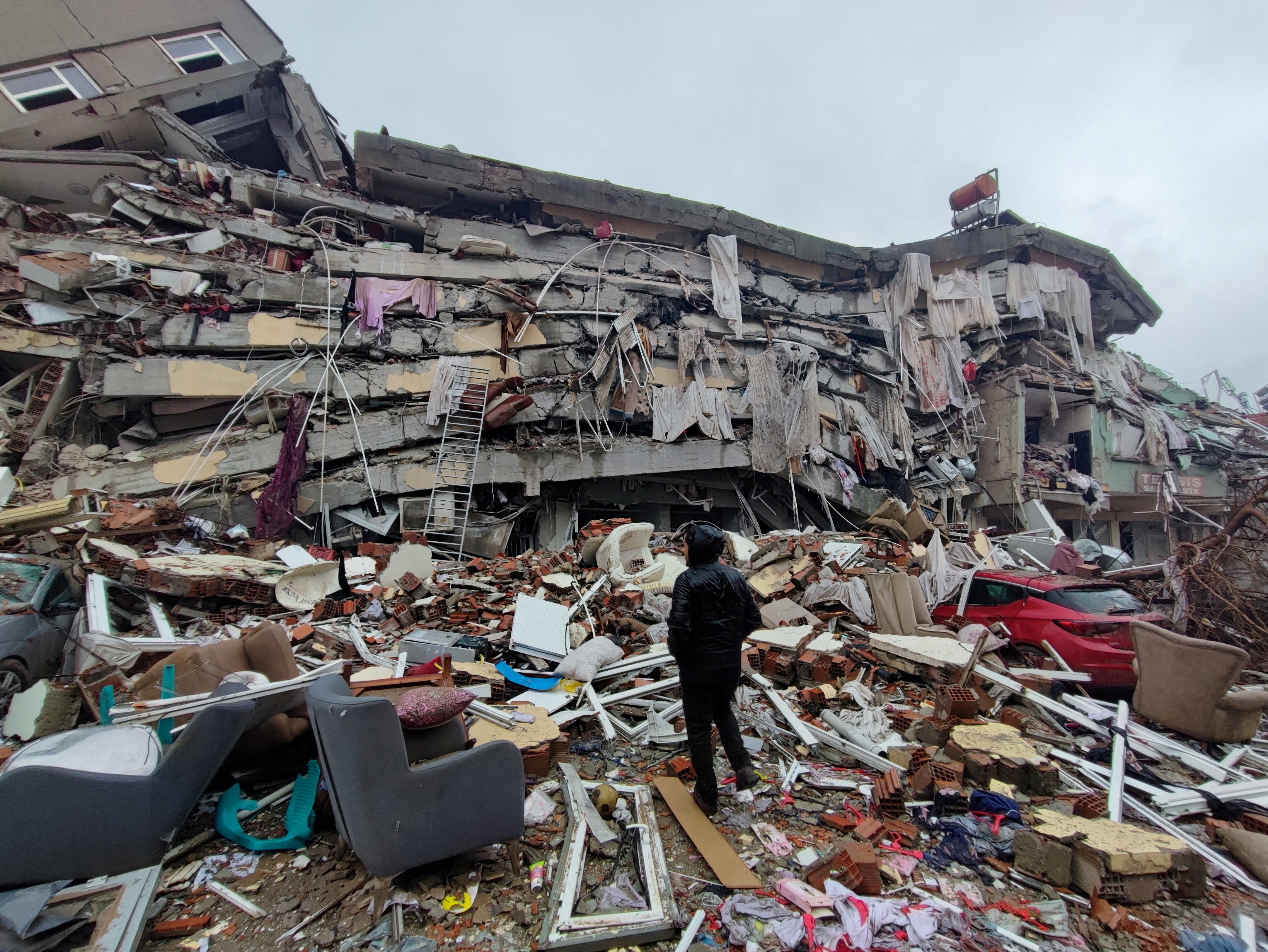
Human Toll and Widespread Damage
The immediate aftermath of the 2017 Iran earthquake was grim. The human toll was catastrophic, with initial reports quickly escalating as rescue efforts began. The quake claimed at least 407 lives and injured over 6,700 others in Iran alone. These numbers primarily reflect the casualties in Kermanshah province, western Iran, which bore the brunt of the devastation. The death toll subsequently rose as more remote areas were reached and victims were recovered from the rubble, though precise final figures can sometimes vary slightly depending on reporting agencies.
Beyond the immediate casualties, the earthquake caused widespread damage across Kermanshah and the Kurdistan region of Iran. Thousands of homes were destroyed or rendered uninhabitable, particularly in rural areas where traditional, less earthquake-resistant construction methods are common. Villages were flattened, and essential infrastructure, including roads, bridges, hospitals, and schools, suffered significant damage. The scale of destruction meant that tens of thousands of people were left homeless, facing the harsh realities of winter in temporary shelters or tents. The impact was not limited to Iran; the earthquake also caused significant damage and casualties in neighboring Iraq, particularly in the Kurdistan Region, underscoring its transboundary nature.
The widespread damage in Kermanshah and Kurdistan region highlighted critical vulnerabilities in building codes and enforcement, especially in older structures or those built without proper seismic considerations. The sheer force of a 7.3 magnitude tremor is immense, but the extent of the tragedy is often amplified by the resilience, or lack thereof, of the built environment. This devastating event quickly became the deadliest earthquake of 2017, a somber testament to its destructive power and the vulnerability of the affected communities.
Geological Mechanisms Behind the Quake: Thrust Faulting
Understanding the geological mechanics behind the 2017 Iran earthquake provides crucial insights into why such events occur in this specific region. Seismologists, including analysis by Jonathan Amos of BBC Science, quickly determined that the tremor resulted from a specific type of fault movement known as thrust faulting. This mechanism is entirely consistent with the ongoing tectonic collision between the Arabian and Eurasian plates that defines Iran's geological landscape.
A simple schematic picture for thrust faulting during the November 2017 event would show the Arabian plate pushing northward beneath the Eurasian plate. This immense compressional force causes rocks to fracture and slide past each other along a fault plane that dips at a relatively shallow angle. In a thrust fault, the hanging wall (the block of rock above the fault) moves upwards and over the footwall (the block below the fault). This upward movement effectively shortens and thickens the Earth's crust, contributing to the formation of mountain ranges like the Zagros, which are characteristic of this region.
The source of this particular earthquake was probably the Zagros fault system in Iran, or a splay fault off the main Zagros trend. The Zagros Mountains are a prime example of a fold-and-thrust belt, formed by the continuous collision of these two massive tectonic plates. The 7.3 magnitude earthquake was a sudden release of accumulated stress along one of these thrust faults, where rocks had been slowly deforming under pressure for decades, perhaps even centuries, before finally slipping. The energy released from this sudden slip propagated through the ground as seismic waves, causing the violent shaking experienced across the border region between Iran and Iraq.
The study of such events, including detailed seismic analysis, helps scientists better understand the dynamics of plate tectonics and improve models for seismic hazard assessment. While predicting the exact timing of an earthquake remains impossible, understanding the types of faults and the stress regimes allows for better long-term preparedness and the development of more resilient infrastructure in areas like Iran, which are perpetually under seismic threat.
A History of Seismic Activity in Iran
The 2017 Iran earthquake, while devastating, is by no means an isolated incident in the country's long and often tragic seismic history. Iran's geological setting ensures that earthquakes are a recurring feature of its landscape. A glance at the historical record reveals a pattern of significant tremors that have shaped its communities and infrastructure over centuries.
Looking back, strong earthquakes near Iran are a regular occurrence. For instance, the United States Geological Survey (USGS) has documented numerous earthquakes in Iran from 1990 to 2006, highlighting the consistent activity along its various fault lines. Prior to the 2017 event, other major quakes have left indelible marks. In 2005, a 6.4 magnitude earthquake rocked the city of Zarand in the southeastern province of Kerman, killing at least 400 people. This event, like many others, underscored the vulnerability of rural areas and older buildings.
Just a few years later, in 2012, a pair of earthquakes jolted northwest Iran, causing significant casualties and damage. These twin quakes, though of slightly lower magnitude than the 2017 event, still demonstrated the destructive potential of even moderate tremors in densely populated or poorly constructed areas. The historical record also includes events like the 1909 Mw 7.4 earthquake, which serves as a benchmark for large-scale seismic activity in the region, illustrating that powerful quakes are not new to Iran.
The recurrence of such powerful events, with the 2017 Iran earthquake being the strongest recent earthquake of the past 10 years near Iran, reinforces the critical need for robust seismic preparedness. Each earthquake, while a tragedy, also offers valuable lessons about geological behavior, building resilience, and effective disaster response. The consistent pattern of seismic activity means that for Iran, earthquake preparedness is not a theoretical exercise but a continuous, vital necessity for protecting its population and preserving its heritage.
Response and Recovery Efforts
The immediate aftermath of the 2017 Iran earthquake saw a massive mobilization of response and recovery efforts, both domestically and internationally. Given the scale of destruction and the high number of casualties, the initial hours and days were critical for search and rescue operations, providing medical aid, and offering emergency shelter to the newly displaced.
Iranian authorities, including the Red Crescent Society, military, and various government agencies, swiftly deployed teams to the affected areas. Challenges were immense: damaged roads hindered access, especially to remote villages, and the sheer volume of rubble made search operations difficult. Despite these obstacles, rescuers worked tirelessly, often by hand, to pull survivors from collapsed buildings. Medical personnel established field hospitals and triage centers to treat the thousands of injured, many of whom required immediate attention for fractures, head injuries, and other trauma.
The international community also responded with offers of aid, though the scope of foreign assistance was somewhat limited by various factors, including sanctions. Nevertheless, humanitarian organizations and some countries provided essential supplies, including tents, blankets, food, and medical kits, to help those left homeless and in dire need. The immediate focus was on providing temporary shelter as winter approached, ensuring access to clean water, and preventing the outbreak of disease in crowded temporary camps.
Beyond the immediate emergency phase, the long-term recovery efforts for the 2017 Iran earthquake began. This involved clearing debris, assessing the full extent of damage, and planning for the reconstruction of homes and infrastructure. The government initiated programs to provide financial aid and materials for rebuilding, but the process was, and continues to be, a monumental undertaking. The psychological impact on survivors, many of whom lost family members and their entire livelihoods, also necessitated long-term support. The recovery from such a devastating event is a multi-year process, requiring sustained commitment and resources to rebuild not just structures, but also lives and communities.
Lessons Learned and Future Preparedness
Every major earthquake, including the 2017 Iran earthquake, serves as a harsh but invaluable teacher. The lessons gleaned from such catastrophic events are crucial for improving future preparedness and mitigating the impact of inevitable seismic activity in highly active regions like Iran. The experience of Kermanshah highlighted several key areas for improvement and reinforced existing best practices.
Building Resilience: Infrastructure and Codes
One of the most critical lessons from the 2017 Iran earthquake was the stark difference in performance between structures built to modern seismic standards and older, more vulnerable buildings. While some newer, engineered buildings withstood the 7.3 magnitude tremor, many traditional mud-brick or poorly constructed concrete structures crumbled, leading to the majority of casualties. This underscores the paramount importance of strict building codes and rigorous enforcement.
For a country like Iran, where 90% of the land is crossed by major faults, investing in earthquake-resistant infrastructure is not a luxury but a necessity. This includes not only residential buildings but also critical facilities such as hospitals, schools, power plants, and communication networks. Retrofitting existing vulnerable structures, especially in densely populated urban areas, is a daunting but essential task. Furthermore, promoting and incentivizing the use of safer construction materials and techniques, particularly in rural areas, is vital to reduce future fatalities and economic losses. The goal is to build resilience into the very fabric of communities, ensuring that buildings can withstand significant shaking and protect their occupants.
Community Engagement and Education
Beyond structural integrity, the 2017 Iran earthquake also emphasized the importance of community-level preparedness. Educating the public about earthquake safety protocols – what to do before, during, and after a quake – can significantly reduce injuries and fatalities. This includes simple yet life-saving actions like "drop, cover, and hold on," having emergency kits, and establishing family communication plans.
Regular earthquake drills in schools and workplaces, public awareness campaigns, and accessible information on seismic hazards are crucial. Empowering local communities with knowledge and resources enables them to respond more effectively in the immediate aftermath, often before external aid can arrive. Strengthening early warning systems, even if they only provide a few seconds of notice, can also be invaluable, allowing people to take protective action. By fostering a culture of preparedness and resilience at all levels, Iran can significantly reduce the human and economic toll of future earthquakes, ensuring that communities are not just reactive but proactively ready for the ground to shake.
Global Context and Comparisons
While the 2017 Iran earthquake was a localized tragedy, it occurred within a global context of seismic activity, reminding us of the Earth's dynamic nature. With a magnitude of 7.3, the November 12, 2017 earthquake that shook the border region between Iran and Iraq is indeed among the largest ever recorded in this specific area, but globally, even larger quakes occur, though often in less populated or remote regions.
For instance, while the 2017 Iran earthquake was the deadliest of that year, other powerful earthquakes have struck different parts of the world. Comparing the 2017 Iran earthquake to other significant events, such as the 2010 Haiti earthquake (magnitude 7.0, but much shallower and closer to a major city, leading to a far higher death toll) or the 2011 Tohoku earthquake in Japan (magnitude 9.1, triggering a devastating tsunami), highlights how a combination of magnitude, depth, proximity to population centers, and building vulnerability determines the ultimate impact. The 2017 Iran earthquake's high casualty count, despite its magnitude, points to the specific vulnerabilities in the Kermanshah region.
The scientific analysis of the 2017 Iran earthquake, as conducted by seismologists and reported by outlets like BBC Science, contributes to a broader global understanding of plate tectonics and seismic hazards. Data from events like this helps refine global seismic models, allowing scientists to better map fault lines, understand stress accumulation, and improve hazard assessments for other seismically active regions worldwide. The shared knowledge and lessons learned from one country's experience can inform preparedness strategies in others, fostering a global community of resilience against natural disasters.
Conclusion
The 2017 Iran earthquake stands as a somber yet powerful testament to the relentless geological forces shaping our planet and the profound impact they can have on human lives. As a nation situated directly atop the collision zone of two major tectonic plates, Iran is inherently prone to frequent and often destructive earthquakes. The 7.3 magnitude tremor that struck Kermanshah province on November 12, 2017, claiming hundreds of lives and devastating communities, was a stark reminder of this enduring vulnerability.
From the scientific understanding of thrust faulting along the Zagros fault to the heart-wrenching human toll and the subsequent arduous recovery efforts, the 2017 Iran earthquake offers invaluable lessons. It underscores the critical importance of robust, enforced building codes, continuous investment in earthquake-resistant infrastructure, and comprehensive public education on preparedness. While we cannot prevent earthquakes, we can significantly mitigate their impact by building more resilient communities and fostering a culture of readiness.
The story of the 2017 Iran earthquake is one of tragedy, but also of resilience and the ongoing human endeavor to live safely in a dynamic world. As we reflect on this event, we are reminded that understanding, preparation, and collective action are our strongest defenses against the unpredictable power of nature. What are your thoughts on the challenges faced by earthquake-prone regions? Share your insights in the comments below, and consider exploring other articles on our site about disaster preparedness and geological phenomena to deepen your understanding.
/nepal-earthquake-2015-858240192-f0cb035a5cd94de98e2ac2ed0f8fe9bc.jpg)
15 Groundbreaking Earthquake Facts

Nature At Its Most Devastating: The Science Of Earthquakes
Pope saddened by 'huge loss of life' after earthquakes in Turkey and
