Iran's Seismic Legacy: Unearthing Centuries Of Earthquake History
Iran, a land rich in ancient history and vibrant culture, is also profoundly shaped by a less visible, yet equally powerful force: its geology. It is well known for its long history of disastrous earthquake activity, a relentless reminder of the dynamic forces beneath its surface. These seismic events have not only claimed countless lives but have also led to the waste of valuable natural resources, leaving an indelible mark on the nation's development and collective memory.
Understanding the earthquake history in Iran is not merely an academic exercise; it is crucial for comprehending the challenges and resilience of its people. From ancient times to the present day, major seismic events have reshaped cities, altered landscapes, and influenced architectural practices. This article delves into the profound impact of earthquakes on Iran, exploring the geological reasons behind its seismic vulnerability, recounting some of its most devastating quakes, and examining the critical lessons learned to build a more resilient future.
Table of Contents
- Iran: A Nation Forged by Tectonic Forces
- A Grim Tally: The Human Cost of Iran's Earthquakes
- Echoes from the Past: Major Earthquakes in Iran's History
- Recent Tremors: Iran's Ongoing Seismic Activity
- Learning from Catastrophe: Building Resilience in Iran
- The Path Forward: Mitigating Future Seismic Impact
- Conclusion: A Seismic Tapestry of Resilience and Understanding
Iran: A Nation Forged by Tectonic Forces
To truly grasp the extensive earthquake history in Iran, one must first understand the underlying geological forces at play. Iran is one of the most seismically active countries in the world, a direct consequence of its geographical position at the convergence of two colossal tectonic plates: the Arabian Plate and the Eurasian Plate. This ongoing collision, a slow but immensely powerful geological ballet, is the main reason for high earthquake activity here. As the Arabian Plate pushes northward into the Eurasian Plate, immense stress accumulates along numerous fault lines that crisscross the Iranian plateau.
These major faults cover at least 90% of the country, making almost every region susceptible to seismic events. From the Zagros Mountains in the southwest to the Alborz range in the north, and the central Iranian plateau, the landscape is a testament to millions of years of tectonic deformation. This complex network of faults, some visible on the surface and others hidden deep underground, acts as conduits for the release of accumulated energy, manifesting as earthquakes. The continuous movement means that Iran is in a constant state of geological flux, making a comprehensive understanding of its seismic framework paramount for safety and development.
A Grim Tally: The Human Cost of Iran's Earthquakes
The human toll of the earthquake history in Iran is staggering, painting a somber picture of repeated devastation. These seismic events are not just geological phenomena; they are profound human tragedies. Since 1900, a chilling figure of at least 126,000 fatalities have resulted from earthquakes in Iran. This number alone speaks volumes about the vulnerability of the region and the immense challenges faced by its inhabitants. The 20th century, in particular, saw a series of catastrophic quakes that decimated communities and left deep scars.
The grim statistics continue into more recent times: around 172,300 people have died in earthquakes since 1950 alone. These figures underscore the relentless nature of seismic activity in Iran and the persistent threat it poses to life and livelihood. Beyond the immediate loss of life, the impact extends to the destruction of homes, infrastructure, and the disruption of daily life for millions. The phrase "waste of valuable natural resources" also highlights the broader economic and environmental consequences, as resources are diverted for reconstruction and recovery, often hindering long-term development and prosperity. Each number represents a life, a family, and a community shattered, emphasizing the urgent need for robust preparedness and mitigation strategies.
Echoes from the Past: Major Earthquakes in Iran's History
To truly appreciate the scope of the earthquake history in Iran, it's essential to look at specific events that have shaped the nation. The following is a chronology of major earthquakes in the past, each offering unique insights into seismic behavior and human response. These events serve as stark reminders of the immense power of nature and the enduring resilience of the Iranian people.
The Salmas Quake of 1930: A Lesson in Foreshocks
One notable event in Iran's seismic past is the 6 May 1930 Salmās earthquake. This M w 7.1 quake struck the fertile Salmās plain, a region that would normally expect high casualties. However, a crucial detail saved many lives: numerous alarming foreshocks helped people staying outdoors during the devastating mainshocks, significantly reducing the number of deaths. About 2,514 people died during this event, which is tragic, but could have been far worse. The majority of people spent the night in the fields after experiencing an M s 5.4 damaging foreshock that took place 10 hours before the main event. This foresight, born from instinct and experience, highlights the critical role that early warning signs, even natural ones, can play in saving lives during seismic crises. It's a poignant example of how human behavior, guided by nature's subtle cues, can mitigate disaster.
The Devastation of 1990: Manjil-Rudbar's Catastrophe
Also, on this day in 1990, one of the world’s most devastating earthquakes struck Iran. This catastrophic event, often referred to as the Manjil-Rudbar earthquake, occurred on June 20th, claiming an estimated 50,000 lives and injuring another 100,000 people. Its immense scale of destruction made it one of the most destructive earthquakes globally in recent memory. The quake, with a moment magnitude of 7.4, devastated vast areas in the Gilan and Zanjan provinces, reducing entire villages to rubble and causing widespread landslides. The sheer number of casualties and the extensive damage underscored the vulnerability of rural infrastructure and the urgent need for improved building codes and disaster response mechanisms in earthquake-prone regions. The 1990 earthquake remains a painful chapter in the earthquake history in Iran, serving as a powerful reminder of the potential for immense human suffering when preparedness is insufficient.
Bam 2003: A City Crumbles
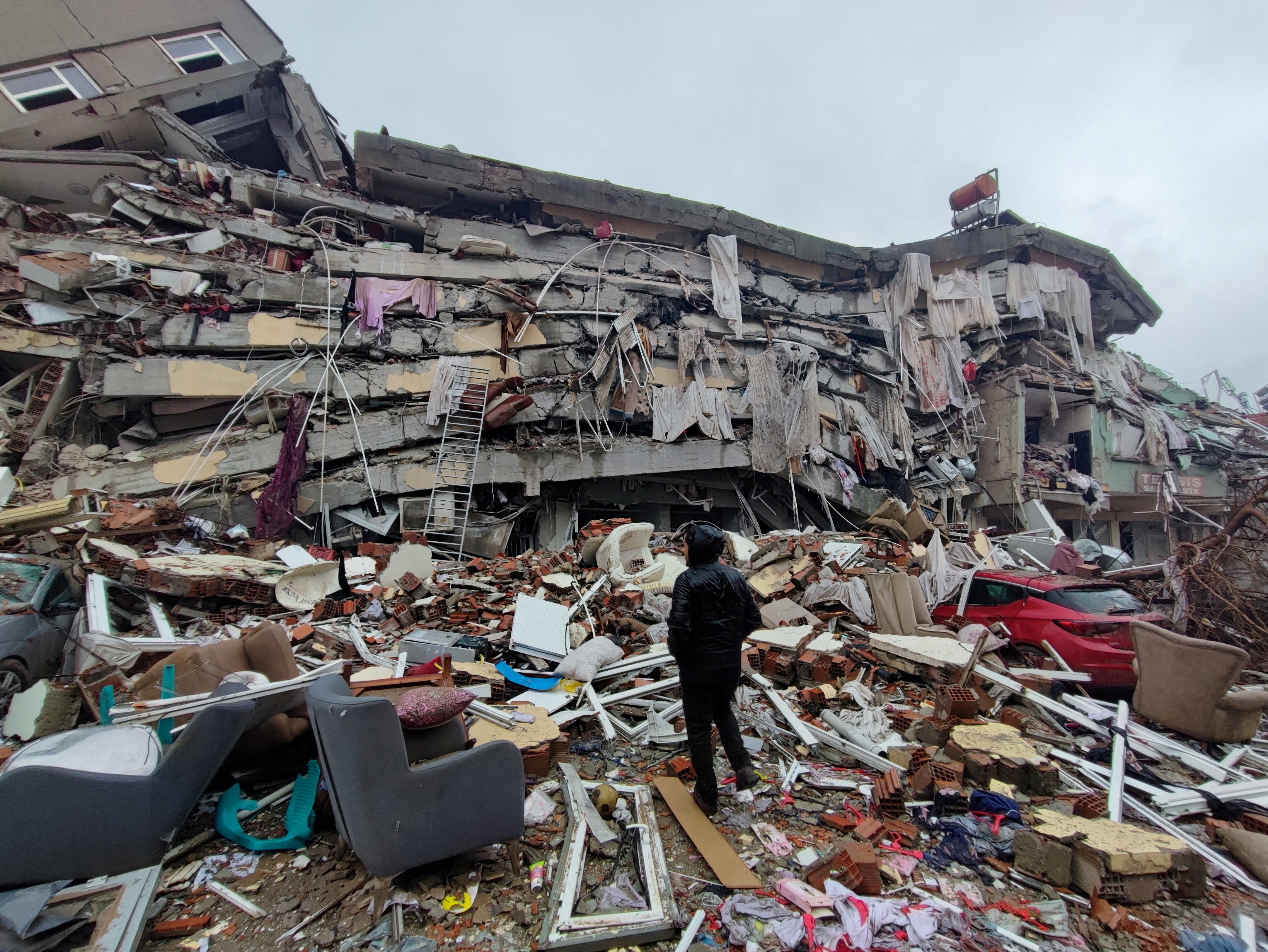
The Bam earthquake of December 26, 2003, though a moderate magnitude seismic event (Mw 6.6) over a period of more than 100 years and among 644 seismic events (fig.2), proved to be one of the deadliest in recent Iranian history. The ancient city of Bam, with its iconic citadel, was almost entirely destroyed, and an estimated 26,271 people lost their lives. The high death toll was attributed to the shallow depth of the earthquake, the poor quality of construction in many of the city's buildings (especially the traditional mud-brick structures), and the time of day it struck (early morning, when most people were asleep). The Bam earthquake highlighted the devastating consequences of inadequate building standards in seismically active zones, prompting a renewed focus on seismic-resistant construction and urban planning in Iran.
Tabriz's Close Call: The 2012 Shallow Quake
More recently, the region near Tabriz experienced a significant tremor. At 23:45 UT, 4:15 AM local time Sunday morning, an incredibly shallow magnitude 6.4 earthquake hit just 58 kilometers from the city of Tabriz, Iran, and the homes of more than a million people. The shallow depth of this earthquake meant that its energy was released very close to the surface, amplifying its destructive potential. Despite its proximity to a major urban center, the immediate casualty figures were lower than some historical quakes, partly due to improved emergency response and potentially a degree of luck. However, it served as a stark reminder of the ever-present threat to densely populated areas in Iran's seismic landscape and the critical importance of preparedness in a region where such events are a constant possibility.
Recent Tremors: Iran's Ongoing Seismic Activity
The earthquake history in Iran is not confined to the distant past; it is an ongoing narrative. The country experiences frequent seismic activity, often registering small to moderate tremors that serve as a constant reminder of the active fault lines beneath. For instance, real-time data often shows a pattern of consistent, though mostly minor, quakes. As an example of this continuous activity, a typical period might see 0 earthquakes of M1.5 or greater in the past 24 hours, but 1 earthquake in the past 7 days, illustrating the ever-present geological movements.
Occasionally, these tremors become more significant, impacting daily life and raising concerns. For example, reports have noted instances where two earthquakes struck Iran early Monday amid ongoing conflict with Israel. While the primary focus of this article is natural seismic activity, it's worth noting that external events, such as an Israeli strike near Iran's nuclear site, have been reported to cause an explosion and tremor, tragically killing 5 people. Such incidents, though distinct from purely natural tectonic movements, highlight the multi-faceted challenges faced by Iran, where geopolitical tensions can sometimes intersect with geological vulnerabilities, adding layers of complexity to an already seismically active region.
Learning from Catastrophe: Building Resilience in Iran
The extensive earthquake history in Iran offers invaluable, albeit often painful, lessons. Each major seismic event, from the foreshock-warned Salmas quake to the devastating Bam catastrophe, provides critical data for scientists, engineers, and policymakers. By drawing valuable lessons from the Iran earthquake history, the nation can significantly enhance its resilience. One of the foremost lessons is the critical need for robust building codes and their strict enforcement. The high death tolls in many historical quakes were often exacerbated by poorly constructed buildings, particularly traditional unreinforced masonry structures.
Gaining a deeper understanding of the complex geological factors that drive seismic activity in the region is also paramount. This involves continuous research into fault lines, plate movements, and seismic wave propagation. Such scientific insight allows for more accurate hazard mapping and risk assessment. Furthermore, embracing innovative tools and technologies for monitoring and predicting earthquakes is essential. This includes advanced seismograph networks, satellite-based deformation monitoring, and AI-driven data analysis. While precise earthquake prediction remains a distant goal, improved monitoring can provide crucial seconds or minutes of warning, and better long-term forecasting can guide urban planning and infrastructure development, ultimately reducing the potential impact of future seismic events and building a safer Iran.
The Path Forward: Mitigating Future Seismic Impact
The journey towards a more resilient Iran, one that can withstand the inevitable future tremors, involves a multi-faceted approach. Building upon the lessons learned from its rich earthquake history, Iran is increasingly focusing on proactive mitigation strategies. This includes investing in seismic-resistant infrastructure, from new buildings to critical facilities like hospitals and schools. Retrofitting existing vulnerable structures is also a massive undertaking, but one that is vital for protecting lives in older, densely populated areas. Urban planning must integrate seismic risk assessment, ensuring that new developments avoid high-risk fault zones and are designed with earthquake safety as a core principle.
Beyond physical infrastructure, public education and preparedness programs are crucial. Ensuring that communities understand what to do before, during, and after an earthquake can dramatically reduce casualties. This includes regular drills, awareness campaigns, and the establishment of robust emergency response systems. International collaboration and knowledge sharing also play a significant role, allowing Iran to leverage global expertise in seismology and disaster management. By combining scientific understanding, technological innovation, sound engineering practices, and community engagement, Iran can significantly reduce the potential impact of future seismic events and build a future where its people can live with greater safety and peace of mind, despite the ever-present threat of earthquakes.
Conclusion: A Seismic Tapestry of Resilience and Understanding
The earthquake history in Iran is a testament to both the immense power of geological forces and the enduring spirit of a nation that has repeatedly faced and overcome profound devastation. From ancient cities crumbled to modern metropolises shaken, the narrative of Iran's seismic past is etched into its landscape and its people's collective memory. We've explored how the convergence of the Arabian and Eurasian plates makes Iran one of the world's most seismically active regions, leading to a grim tally of fatalities and significant resource waste over centuries.
Through a chronology of major events like the Salmas quake, the devastating 1990 Manjil-Rudbar earthquake, the tragic Bam disaster, and the shallow Tabriz tremor, we've seen how each event has offered painful yet invaluable lessons. These lessons, combined with a deeper understanding of complex geological factors and the embrace of innovative monitoring technologies, are paving the way for a more resilient future. By continuing to invest in seismic-resistant construction, public education, and robust emergency response, Iran can significantly reduce the potential impact of future seismic events and build a safer, more prepared society.
What are your thoughts on how communities can best prepare for earthquakes? Share your insights in the comments below. If you found this exploration of Iran's seismic legacy insightful, consider sharing it with others, and explore more articles on our site about natural disaster preparedness and geological phenomena.
- Noarmsgirl Only Fans
- Faith Jenkins Net Worth 2024
- Vega Foo
- Seo Rank Tracking Software With Tasks
- How Did Bloodhound Lil Jeff Die
/nepal-earthquake-2015-858240192-f0cb035a5cd94de98e2ac2ed0f8fe9bc.jpg)
15 Groundbreaking Earthquake Facts

Nature At Its Most Devastating: The Science Of Earthquakes
Pope saddened by 'huge loss of life' after earthquakes in Turkey and
