Unraveling Earthquake Forecasts In Iran: Science, History, And Preparedness
Iran, a land steeped in ancient history and vibrant culture, also lies squarely atop one of the most seismically active regions on Earth. The constant tremor of the planet beneath its surface makes the topic of earthquake forecasting not merely an academic exercise, but a critical concern for millions. Understanding the intricate dance of tectonic plates, interpreting subtle seismic signals, and preparing for the inevitable are ongoing challenges that define life in this geologically dynamic nation. This article delves into the complex world of earthquake forecasting in Iran, exploring the scientific efforts, historical impacts, and the crucial need for informed public awareness in a region where the ground frequently shifts.
From minor tremors to devastating quakes, Iran's seismic activity is a daily reality. While the concept of precise earthquake prediction remains elusive for scientists worldwide, the field of earthquake forecasting – which focuses on probabilistic assessments and long-term risk evaluation – is vital. We will explore the current state of seismic monitoring, the historical context of major quakes, and the dedicated work of institutions striving to enhance our understanding and resilience in the face of nature's powerful forces.
Table of Contents
- A Nation on Fault Lines: Iran's Geologic Reality
- Recent Tremors: A Snapshot of Activity
- Beyond Prediction: The Nuances of Earthquake Forecasting
- The Role of IIEES: A Scientific Approach
- Echoes of the Past: Iran's Devastating Earthquakes
- The Human Cost and Resilience
- Navigating the Noise: Separating Science from Speculation
- The Eyes and Ears on the Ground: Monitoring Iran's Seismic Activity
- Building Resilience: Preparing for Iran's Seismic Future
A Nation on Fault Lines: Iran's Geologic Reality
Iran's geographical position places it at the collision zone of the Arabian, Eurasian, and Indian tectonic plates, making it one of the most seismically active countries globally. This geological reality means that the ground beneath Iran is constantly under immense stress, leading to frequent seismic events. The country is crisscrossed by numerous active fault lines, some of which are capable of generating very powerful earthquakes. This inherent instability underscores the importance of continuous seismic monitoring and the development of robust strategies for earthquake preparedness and, where possible, earthquake forecast Iran.
The sheer frequency of tremors is a testament to this activity. Over the past year, Iran has experienced a significant number of seismic events. Specifically, in the past 365 days, there have been 120 earthquakes of magnitude 1.5 or greater. This continuous low-level activity is a constant reminder of the underlying tectonic pressures. While many of these quakes are minor and go unnoticed by the general public, they are crucial data points for seismologists trying to understand the long-term patterns and energy build-up along fault lines. The data indicates a consistent seismic pulse, reflecting the dynamic geological processes at play beneath the Iranian plateau.
Recent Tremors: A Snapshot of Activity
Looking at more recent data provides a clearer picture of the immediate seismic environment. In the past 30 days, Iran has recorded 9 earthquakes. Narrowing this down further, the past 7 days saw 4 earthquakes, and in the last 24 hours, there were 2 earthquakes of magnitude 1.5 or greater. The most recent recorded earthquake was a magnitude 2.5, indicating that while tremors are frequent, many are of a smaller scale. These smaller quakes, often imperceptible to humans, are vital for scientific analysis, providing insights into the ongoing stress accumulation and release within the Earth's crust.
It's important to note that while these numbers reflect ongoing activity, they do not necessarily indicate an imminent major event. The vast majority of earthquakes are small, and only a tiny fraction are strong enough to cause damage. However, this consistent seismic background is what makes the work of institutions focused on earthquake forecast Iran so critical. The data points, visualized often as circles sized by magnitude (red for less than 1 hour old, blue for less than 1 day, yellow for less than 1 week), allow researchers to track activity and identify potential areas of concern, though precise prediction remains an aspiration rather than a reality.
Beyond Prediction: The Nuances of Earthquake Forecasting
The terms "earthquake prediction" and "earthquake forecasting" are often used interchangeably in popular discourse, but in seismology, they carry distinct meanings. True earthquake prediction, which would specify the exact time, location, and magnitude of a future earthquake with high certainty, is currently not scientifically possible. The Earth's crust is incredibly complex, and the processes leading to earthquakes are not yet fully understood or measurable with the precision required for such predictions.
However, earthquake forecasting is a different endeavor. It involves assessing the probability of an earthquake occurring in a particular region over a specific timeframe (e.g., decades or years), often based on historical seismic activity, geological studies, and an understanding of fault mechanics. This probabilistic approach is crucial for long-term planning, building codes, and public preparedness. The goal of earthquake forecast Iran is to understand the likelihood of future events, not to pinpoint them precisely. This scientific distinction is vital for managing expectations and directing resources effectively.
The Role of IIEES: A Scientific Approach
In Iran, a key player in this scientific pursuit is the IIEES Earthquake Prediction Center (International Institute of Earthquake Engineering and Seismology). This center stands as a scientific and research entity dedicated to analyzing seismological data. Their work is fundamental to understanding Iran's seismic hazards. The IIEES focuses on probabilistic and precursory methods, conducting research related to earthquake prediction (or more accurately, forecasting) in Iran and the surrounding regions.
Their research involves monitoring seismic waves, studying ground deformation, and analyzing historical earthquake patterns. By meticulously collecting and interpreting this data, the IIEES aims to improve our understanding of earthquake mechanisms and contribute to more accurate hazard assessments. While they do not issue specific, short-term predictions, their work provides the scientific foundation for informed decision-making regarding infrastructure, urban planning, and public safety initiatives across Iran. Their commitment to rigorous scientific methodology is paramount in a field where public anxiety can easily be fueled by unsubstantiated claims.
Echoes of the Past: Iran's Devastating Earthquakes
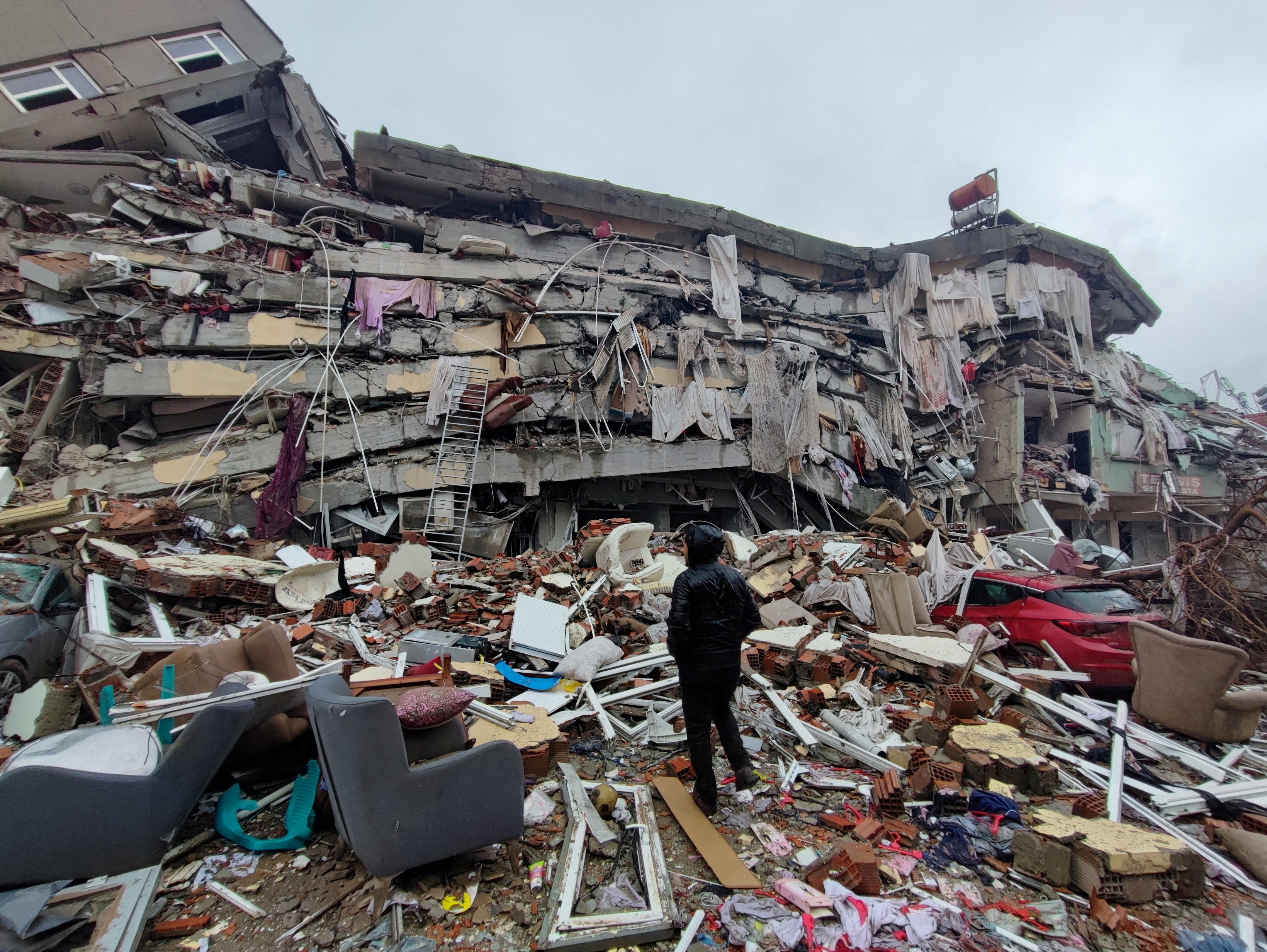
Iran's history is punctuated by numerous devastating earthquakes, each leaving an indelible mark on the landscape and the collective memory of its people. These historical events serve as stark reminders of the immense power of nature and the critical need for resilience and preparedness. Understanding these past events is crucial for any meaningful discussion about earthquake forecast Iran, as they provide invaluable data for seismic hazard assessment and risk mitigation.
The largest quake that occurred in or near Iran during the past 10 years was a magnitude 7.2 earthquake that struck Kermanshah province, Iran, 8 years ago on Sunday, November 12, 2017, at 09:48 PM local time (Asia/Tehran GMT +3:30). This powerful temblor happened at 9:19 p.m. Iran time, about 22 miles southwest of the city. The sheer force of this earthquake was immense, releasing an estimated total seismic energy of 7 x 10^13 joules. To put this into perspective, this is equivalent to 19.4 gigawatt hours, or the explosive power of 16,675 tons of TNT, which is roughly equivalent to one atomic bomb. Such an event underscores the catastrophic potential of major quakes in the region, highlighting the vulnerability of structures and the profound impact on human lives.
The Human Cost and Resilience
The Kermanshah earthquake, like many others before it, resulted in significant loss of life, widespread destruction of infrastructure, and immense human suffering. The impact extended beyond immediate casualties, leading to long-term displacement, economic hardship, and psychological trauma for affected communities. These events serve as a harsh lesson in the importance of robust building codes, effective emergency response systems, and comprehensive disaster preparedness plans. The resilience of the Iranian people in the face of such adversity is often remarkable, with communities coming together to rebuild and support one another.
Despite the high seismic activity, with 319 earthquakes recorded recently, it's notable that there have been no quakes of magnitude 6 or higher in the immediate past period referenced by some data. While this is a positive short-term observation, the historical record, particularly the 2017 Kermanshah quake, reminds us that the potential for such powerful events always exists. Learning from these past tragedies is a continuous process, informing strategies for urban development, infrastructure resilience, and public education to minimize future losses. The goal is not just to survive, but to thrive in a seismically active environment, and this involves constant vigilance and adaptation.
Navigating the Noise: Separating Science from Speculation
In an age of instant information and widespread social media, the discourse around natural disasters, particularly earthquakes, is often muddled by speculation, unverified claims, and even outright misinformation. The public's understandable anxiety about seismic events makes them susceptible to sensationalized "predictions" that lack scientific backing. This creates a significant challenge for scientists and official bodies trying to communicate accurate information and foster genuine preparedness.
One notable example of this phenomenon is the "Hooogerbeets' prediction," which gained viral traction. After his prediction went viral, he reacted to an earthquake, stating, "As I stated earlier, sooner or later this would happen in this region, similar to the years 115 and 526." While such statements might seem prescient to some, they often rely on vague pronouncements that can be retrofitted to fit any event. True scientific forecasting, in contrast, relies on empirical data and established physical principles, not on historical analogies or intuition. The scientific community largely dismisses such claims as lacking the specificity and verifiable methodology required for genuine prediction.
Further contributing to this landscape of speculation are various non-scientific "predictions" that capture public imagination. For instance, there's mention of a "New Baba Vanga prediction 2025" and a manga that warns that on July 5, 2025, "a crack will open up under the seabed between Japan and the Philippines, sending ashore waves three times as tall as those from the Tohoku earthquake." While these narratives might be compelling, they fall squarely into the realm of fiction or folklore, not science. It is crucial for the public to differentiate between such sensationalized claims and the diligent, peer-reviewed work of seismologists and geological institutions when seeking information about earthquake forecast Iran or anywhere else in the world.
The Eyes and Ears on the Ground: Monitoring Iran's Seismic Activity
In the absence of precise earthquake prediction, continuous and sophisticated seismic monitoring becomes the cornerstone of earthquake preparedness. Scientists rely on a vast network of seismographs and other instruments to detect, locate, and measure earthquakes as they happen. This real-time data collection is fundamental to understanding the Earth's dynamic processes and providing immediate information to authorities and the public.
Modern seismic monitoring systems provide detailed information about today's earthquakes, including lists of the biggest and most recent events. Earthquakes are typically shown on maps as circles, with their size indicating magnitude and their color denoting recency (red for less than 1 hour old, blue for less than 1 day, yellow for less than 1 week). Users can click or tap on a circle to view more details about an earthquake, such as its exact location, date/time, magnitude, and links to more information. The local time displayed is the time of the earthquake in the user's computer's time zone, making the information immediately relatable.
Information such as magnitude, depth, and maximum intensity is calculated live as seismic waves are recorded. This rapid analysis allows for quick dissemination of critical data, which is essential for emergency response. While the data might show periods of relative calm – for example, some specific regions might report "0 earthquakes in the past 24 hours, 0 earthquakes in the past 7 days, 0 earthquakes in the past 30 days, 3 earthquakes in the past 365 days" for smaller magnitude ranges (like m1.5 or greater) – this doesn't mean seismic activity has ceased entirely across the entire country. It simply reflects the localized nature of some monitoring efforts or the threshold for reporting. The overall picture for earthquake forecast Iran relies on comprehensive, nation-wide monitoring networks that feed into scientific research and public information systems.
Building Resilience: Preparing for Iran's Seismic Future
Given Iran's inherent seismic vulnerability, the focus for the future must remain firmly on building resilience. This involves a multi-faceted approach that integrates scientific research, robust infrastructure development, public education, and effective emergency response planning. The insights gained from institutions like the IIEES are invaluable in this ongoing effort to mitigate the risks associated with living in a seismically active zone.
Continued investment in seismic monitoring technology and research into earthquake forecasting methods is paramount. While precise prediction remains out of reach, advancements in understanding precursory signals and improving probabilistic models can provide increasingly valuable insights for long-term planning. This includes developing more sophisticated early warning systems, even if they only provide seconds of notice, as those seconds can be life-saving.
Beyond scientific endeavors, practical measures are crucial. Enforcing and updating building codes to ensure structures can withstand strong shaking is fundamental. Public awareness campaigns are essential to educate citizens on what to do before, during, and after an earthquake. This includes promoting earthquake drills, establishing clear evacuation routes, and ensuring communities have access to emergency supplies. The ongoing geopolitical situation, such as "heightened military tensions with Israel" or "Iran retaliated with approximately 100 drones aimed at Israeli territory," while unrelated to seismic activity, can sometimes divert attention or resources. However, the constant threat of earthquakes demands unwavering focus on preparedness, regardless of other external factors.
Ultimately, preparing for Iran's seismic future is a continuous journey of learning, adapting, and strengthening. It requires collaboration between scientists, engineers, government agencies, and the public. The goal is not to eliminate the threat of earthquakes – which is impossible – but to minimize their impact, protect lives, and ensure that communities can recover and rebuild effectively. The emphasis must always be on informed action, guided by the best available scientific data, rather than succumbing to fear or unsubstantiated claims. This proactive approach to earthquake forecast Iran is the most reliable path forward.
Conclusion
The intricate reality of earthquake forecast Iran is a testament to both the relentless power of nature and the unwavering dedication of human ingenuity. We've explored Iran's position on active fault lines, its frequent seismic tremors, and the significant historical impact of major quakes like the 2017 Kermanshah event. Crucially, we've differentiated between the elusive concept of precise earthquake prediction and the scientifically grounded field of earthquake forecasting, highlighting the vital work of institutions like the IIEES in providing probabilistic assessments and analyzing crucial seismological data.
Understanding the difference between scientific information and speculative claims is paramount in a world saturated with information. While sensational "predictions" may capture attention, it is the continuous, meticulous monitoring and research by dedicated scientists that truly contribute to public safety and resilience. Iran's ongoing efforts to enhance its seismic monitoring capabilities and strengthen its preparedness measures are critical steps towards mitigating the risks inherent in its geological landscape.
The ground beneath Iran will continue to shift, but with sustained scientific inquiry, robust infrastructure, and an informed, prepared populace, the nation can face its seismic future with greater confidence. We encourage you to stay informed by consulting official scientific sources for earthquake information and to actively participate in local preparedness initiatives. Share this article to help spread awareness about the importance of scientific understanding in the face of natural hazards, and explore other resources on our site to deepen your knowledge of seismic safety and resilience.
/nepal-earthquake-2015-858240192-f0cb035a5cd94de98e2ac2ed0f8fe9bc.jpg)
15 Groundbreaking Earthquake Facts

Nature At Its Most Devastating: The Science Of Earthquakes
Pope saddened by 'huge loss of life' after earthquakes in Turkey and
