Iran's Shifting Ground: Understanding Its Seismic Hotspot
Iran, a nation steeped in ancient history and vibrant culture, also sits on one of the most geologically dynamic regions on Earth. Its landscape, sculpted over millennia, is a testament to immense subterranean forces. However, this geological activity comes with a profound cost: the constant threat of devastating earthquakes. Understanding the intricate network of Iran fault lines is not merely an academic exercise; it's a critical imperative for the safety and resilience of millions. This comprehensive exploration delves into the geological realities that define Iran's seismic vulnerability, examining the science behind its frequent tremors, the ongoing efforts to map and understand these subterranean threats, and the broader implications for a nation living on the edge of tectonic plates.
From the towering peaks of the Zagros Mountains to the vast expanses of the Lut Desert, nearly every corner of Iran bears the imprint of active tectonics. This article will provide an in-depth look at why Iran is so prone to seismic events, drawing on scientific data and expert insights to paint a clear picture of the risks and the knowledge being gathered to mitigate them. We will navigate the complexities of plate tectonics, explore the characteristics of Iran's major fault systems, and discuss how historical seismic activity informs our current understanding of this volatile region.
Table of Contents
- Iran's Unstable Foundation: A Seismic Hotspot
- Mapping the Danger: Comprehensive Fault Line Data
- Major Geological Faults: Architects of Landscape and Destruction
- Active Faults: A Constant Threat
- Historical Echoes: Earthquakes and Their Legacy
- Scientific Insights: Deduced from Earthquakes, Faulting, and GPS
- The Broader Context: Beyond Geology
- Mitigating Risk: Preparing for the Inevitable
Iran's Unstable Foundation: A Seismic Hotspot
Iran is unequivocally one of the most seismically active countries in the world. This profound geological reality is not a matter of chance but a direct consequence of its geographical location. The country is crisscrossed by several major faults that collectively cover at least 90% of its landmass. As a result, earthquakes in Iran occur often and are frequently destructive, leaving a trail of human suffering and infrastructural damage. Over 90% of Iran resides in an active seismic zone, making it a region of extreme risk for earthquakes. This inherent instability means that the ground beneath Iranian cities and villages is in a perpetual state of subtle, yet powerful, motion. The constant threat necessitates a deep understanding of these geological forces to inform urban planning, infrastructure development, and disaster preparedness.The Tectonic Tapestry: Plates in Collision
At the heart of Iran's seismic vulnerability lies its position at the convergence of three colossal tectonic plates: the Arabian, Eurasian, and Indian plates. Iran sits atop a major fault line, a direct consequence of these plates grinding against each other. The Arabian plate is relentlessly pushing northward into the Eurasian plate, a slow-motion collision that has been ongoing for millions of years. This immense pressure is accommodated by a complex network of fault systems across the Iranian plateau. The Indian plate's influence, though more distant, also contributes to the overall stress field. This convergence zone is not uniform; different parts of Iran experience varying degrees and types of deformation, from compression and thrust faulting in the west to more extensional tectonics in the east. The Iranian faults are classified based on their trends, reflecting the diverse ways in which the crust responds to these powerful tectonic forces. This dynamic interplay of plates is the fundamental reason why Iran is highly prone to seismic activity.Mapping the Danger: Comprehensive Fault Line Data
Understanding the precise location and characteristics of Iran's fault lines is paramount for assessing seismic risk. Geological surveys and mapping efforts are continuous, with data sets like "Major faults in Iran (flt2cg) metadata" being regularly updated. For instance, a significant update occurred on July 6, 2024, for the geology data set, which includes arcs, polygons, and labels that outline and describe the general geologic age and type of bedrock of Iran. Such detailed geological mapping provides the foundational knowledge necessary for identifying areas of high seismic potential. These maps are not static; they evolve as new data emerges from field studies, satellite imagery, and seismic monitoring. The complexity of Iran's geology, with its diverse rock types and intricate fault patterns, requires a multi-faceted approach to mapping.Evolving Data and Public Access
The commitment to understanding Iran's seismic landscape is further evidenced by the continuous refinement of geological data. The second version of the major faults map, updated in 2011, represents a significant leap forward. This version not only contains the latest information on active faults in Iran but also includes digital files of the faults with available data for each fault. This crucial information encompasses parameters such as strike, dip, rake, mechanism, slip rate, and seismic history. Making such detailed data available to the public, often on CD, underscores a dedication to transparency and shared knowledge within the scientific community and for practical applications. The layout of maps showing geology, oil and gas fields, geologic provinces, and major faults of Iran is typically produced using specialized software like ArcPlot, utilizing Arc/Info coverages described in metadata files. This systematic approach ensures that researchers and urban planners have access to the most accurate and up-to-date information for risk assessment and mitigation strategies.Major Geological Faults: Architects of Landscape and Destruction
The major fault lines traversing Iran are not merely lines on a map; they are the architects of the country's dramatic topography and the primary drivers of its seismic events. These faults, formed over millions of years of tectonic activity, dictate where mountains rise and where basins form. While this fault line was responsible for the creation of the Zagros Mountain Range, a majestic chain stretching across western Iran, it has also been the cause of a multitude of devastating earthquakes. The Zagros, a prime example of an active fold-and-thrust belt, is a direct consequence of the ongoing collision between the Arabian and Eurasian plates. The sheer scale of the forces involved means that even seemingly minor movements along these faults can release tremendous energy, leading to significant seismic events.The Mighty Zagros Fault System
Though the most major fault line present within Iran is undoubtedly the Zagros, it is certainly not the only one. Iran's fault network is highly complex, featuring numerous other significant fault systems that contribute to its overall seismic hazard. These include, but are not limited to, faults associated with the longitudinal extension of the Lut Desert, and those affecting the southern islands of Iran, Qatar, and the United Arab Emirates. Each of these fault systems has its own unique characteristics, including their geometric properties, mechanisms of movement, and seismic potential. For instance, detailed studies might show solid lines representing positions of fault planes from inversion after adjustment for topography, or gray fill illustrating features like the Shahdad thrust wedge. An average of two interferograms, converted to radar range change, can provide insights into ground motion in millimeters, further detailing the subtle shifts along these critical geological structures. The Shotori fault near Zerk village (located at 33°25′45″N, 57°13′38″E) is an example of a specific fault where the fault's effect line can be indicated by white arrows, and the fault plane's location marked by a red star, allowing for precise study of its behavior.Active Faults: A Constant Threat
The term "active fault" is crucial in understanding Iran's seismic risk. An active fault is defined as a fault which has moved repeatedly in recent geological time and has the potential for reactivation in the future. This definition implies that these faults are not dormant but are continuously accumulating stress, which will eventually be released as an earthquake. Virtually all major faults in Iran are active and thus have great seismic potential. This means that almost any significant fault line across the country could be the source of a future earthquake. While extensive research has been conducted, the study of active faults has not always been detailed enough in Iran, meaning we cannot be certain about the precise behavior or recurrence intervals of every fault. However, what is known is alarming: there are active faults from Hamedan in the west to Gilan in the north that may cause a deadly earthquake at any moment. This widespread distribution of active faults underscores the pervasive nature of the seismic threat across Iran.Historical Echoes: Earthquakes and Their Legacy
The history of earthquakes within Iran provides a sobering testament to the destructive power of its fault lines. Records show numerous devastating events throughout centuries, with significant seismic activity documented, for example, from 1990 to 2006 by the United States Geological Survey (USGS). These historical records indicate that Iran's faults are usually seismogenic, meaning they are capable of generating earthquakes. They have produced many destructive events even when some of the major faults were quiescent, suggesting that smaller, less-studied faults can also pose significant threats. Each historical earthquake offers valuable data, helping scientists understand the behavior of specific fault segments, their slip rates, and the magnitude of events they can generate. Analyzing these past events is critical for probabilistic seismic hazard assessment, allowing researchers to estimate the likelihood and potential intensity of future earthquakes in different regions of Iran.Scientific Insights: Deduced from Earthquakes, Faulting, and GPS
Modern scientific methods are continuously refining our understanding of Iran's active tectonics. Research papers, such as "Active tectonics of Iran deduced from earthquakes, active faulting and GPS evidences," highlight the multi-disciplinary approach taken by geoscientists. In such papers, active faults of Iran are considered in detail, analyzing their geometric characteristics, mechanisms, and the trend of active fault zones in different areas of Iran, while also considering their tectonic differences. The integration of data from various sources – including seismic records, geological mapping of surface ruptures (active faulting), and precise measurements from Global Positioning System (GPS) networks – provides a comprehensive picture of crustal deformation. GPS data, in particular, can detect minute movements of the Earth's surface, revealing how strain is accumulating along fault lines. This allows scientists to identify areas where stress is building up, potentially indicating future earthquake locations. The scientific diagram showing a "map of active faults of Iran (Hessami, 2003)" is an example of how these insights are synthesized and presented, offering a visual representation of the country's complex seismic landscape.The Broader Context: Beyond Geology
While this article primarily focuses on the geological "Iran fault lines," it's important to acknowledge that the term "fault lines" is also used metaphorically in broader geopolitical discussions. One might "explore the tumultuous landscape of modern geopolitics in 'fault lines of a new world'," where the phrase refers to deep divisions or points of potential conflict between nations or ideologies. Indeed, the "fault lines in this coordination are already visible" in international relations, reflecting fundamental disagreements. For instance, discussions about "war hawks in Washington" viewing a situation as "a strategic opening and an opportunity to decisively weaken Iran" illustrate such metaphorical fault lines. Similarly, concerns about "Israeli strikes on Iranian oil fields could choke this flow, spiking prices and imperiling China’s fragile" economy, or political figures like "Trump and conservative media personality Tucker Carlson have traded barbs over the 'America First' doctrine," all speak to profound divisions. While these geopolitical "fault lines" are distinct from geological ones, they highlight how deep-seated divisions, whether in the Earth's crust or in human society, can lead to instability and dramatic shifts. It's a powerful metaphor that underscores the fragility inherent in complex systems, both natural and political. However, for the purpose of this article, our focus remains firmly on the tangible, life-altering geological fractures that define Iran's physical reality.Mitigating Risk: Preparing for the Inevitable
Given the pervasive nature of Iran's fault lines and the certainty of future earthquakes, mitigation strategies are not just advisable but absolutely essential. These strategies encompass several key areas: * **Building Codes and Urban Planning:** Strict adherence to earthquake-resistant building codes is paramount, especially in densely populated urban centers. Urban planning must consider fault proximity, soil liquefaction potential, and landslide risks. * **Public Awareness and Education:** Educating the public about earthquake preparedness – what to do before, during, and after an earthquake – can significantly reduce casualties. Regular drills and public information campaigns are vital. * **Early Warning Systems:** While predicting earthquakes with precision remains elusive, early warning systems that detect the initial seismic waves can provide crucial seconds or minutes of warning, allowing for automated shutdowns of critical infrastructure and enabling people to take cover. * **Infrastructure Resilience:** Investing in the resilience of critical infrastructure, such as hospitals, schools, power grids, and transportation networks, ensures that essential services can continue or be rapidly restored after an earthquake. * **Continued Research and Monitoring:** Ongoing scientific research into the behavior of Iran's fault lines, coupled with continuous seismic monitoring, is crucial for refining hazard assessments and informing mitigation efforts. The detailed data available for each fault, including slip rates and seismic history, must be continuously updated and analyzed. By systematically addressing these areas, Iran can move towards a future where its vulnerability to earthquakes is managed more effectively, transforming a constant threat into a challenge that can be prepared for and endured.Conclusion
Iran's position at the nexus of three major tectonic plates renders it one of the most seismically active nations globally. The extensive network of Iran fault lines, including the mighty Zagros system and countless other active segments, dictates a landscape of both majestic beauty and inherent danger. Scientific efforts, supported by organizations like the USGS and detailed mapping initiatives, continuously strive to unravel the complexities of these subterranean forces, providing invaluable data on fault characteristics, historical seismic events, and active crustal deformation. The reality for Iran is that earthquakes are not a matter of "if," but "when." This understanding underscores the critical importance of robust earthquake preparedness, resilient infrastructure, and an informed populace. While the geological challenges are immense, ongoing research, public education, and proactive urban planning offer pathways to mitigate the devastating impact of future seismic events. By embracing scientific insights and implementing comprehensive safety measures, Iran can build a more resilient future for its people, ensuring that life can continue to thrive amidst the Earth's powerful, shifting ground. We encourage you to share your thoughts on Iran's seismic challenges in the comments below. Have you experienced an earthquake, or do you have insights into disaster preparedness in active seismic zones? Your experiences and perspectives are valuable. For more articles on geological phenomena and disaster preparedness, please explore other sections of our website.- Claire Anne Callens
- Preetyscale
- Averyleigh Onlyfans Sex
- Maria Temara Leaked Videos
- Michael Steele Wife
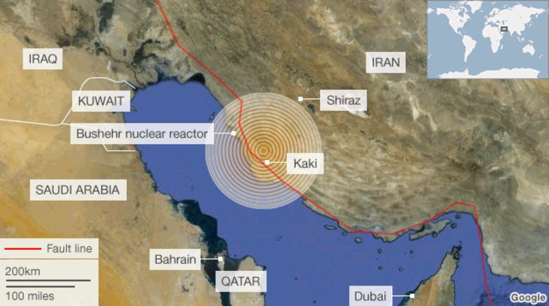
Deadly quake in south-west Iran's Bushehr province - BBC News

Magnitude 7.3 Earthquake In Iran-Iraq Is The Deadliest Of 2017

(a) Tectonic setting of Iran in the Middle East and presentation of
